Aftershock Deployment in Wine Country


| On August 27, 3:22 am Napa, California experienced a M=6.0 earthquake, causing significant damage to buildings in downtown and in the world-renowned vineyards of central Californa. Dr. Rufus Catchings of the USGS' Menlo Park office led a deployment team consisting of USGS staff and volunteers, supported by George Slad of PASSCAL. |
|
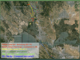
Catchings' initially proposed a deployment of three geophone arrays; two straddling the Napa fault, upon which the earthquake occurred, and one more south of the Bay, straddling the Franklin fault, as it was hypothesized that the Napa Fault may be connected to the Franklin Fault immediately to the south. Aftershocks along the fault traveling within the fault's low velocity zone may illuminate whether or not the West Napa Fault and the Franklin Fauilt are connected. Subsequently Catchings and his colleagues at the USGS supplemented the arrays with a loose grid of single component Reftek Texan dataloggers and geophones and Reftek RT-130 and Guralp CMG-40T-1sec stations. |
|
Hurry up and wait... There wasn't a lot of waiting, at least until after George Slad landed at Napa County airport in his RV-4 homebuilt and met with Martin Pehl, Airport Manager, as the equipment, Fedex'ed to Menlo Park, was still in transit to Napa. With thousands of businesses and residences out of power after the earthquake and the airport relatively undamaged, George contacted Martin immediately after being assigned support of the deployment and inquired into the possibility of the Airport providing a facility from which the team could store, test, and deploy equipment and later download data during the effort. Martin Pehl, recognizing the importance of the aftershock deployment, arranged for the use of a large vacant hangar - free of charge -- and the local fixed base operator, Napa Jet Center, provided the team internet access and use of their copy machine. -- Thank you Napa County Airport and Napa Jet Center! -- The choice of the airport as the instrument center provided a relatively centralized and secure location from which to operate, was close to a major highway, and also served as a site for one of the short-period stations.
It's worth noting the surface expression of the fault passed through the center of the airport, causing some cracking of pavement on one taxiway. Air traffic controllers had to operate out of a temporary tower as the permanent tower had all of its windows shattered by the shaking of the earthquake.
Time-Line: Earthquake Through Deployment:
Sunday, August 24, 3:20:44 AM PDT: M=6.0 earthquake
Monday morning, August 25: USGS contacts PIC regarding the desire to do a RAMP deployment
Tuesday morning, August 26: USGS approves funds for deployment effort
Tuesday ~11 am PDT, August 26: Equipment leaves PASSCAL Instrument Center via Fedex
Wednesday 8:37 am PDT, August 27: George leaves Albuquerque for Napa
Wednesday 3:53 pm PDT: George arrives at Napa
Wednesday ~6 pm PDT: PASSCAL equipment arrives at Napa
Wednesday ~11:30 pm PDT: Reftek 125A Texans are programmed, ready for deployment the next morning
Thursday 2:45 pm PDT, August 28: installation of 50 stations completed (consisting of 150 Texans and L-28 sensors)
Friday 5:59 pm PDT, August 29: 6 short-period stations installations completed
Saturday 6:06 pm PDT, August 31: Geophone grid installations completed
|
|
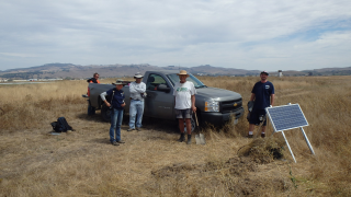
USGS staff and volunteers complete the installation of their first short period station, located immediately south of the approach end of runway 6 at the Napa County Airport, within a kilometer of the fault's surface expression passing through the airport property. |
|
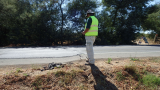
Rufus Catchings observing evidence of fault movement along a road to the middle linear array, installed northwest of the airport. |
|