User login

Here are some of the articles that have been recently posted to the PASSCAL website:

Western Idaho Shear Zone: is snow in the forecast?

FlexArray Experiment: Western Idaho Shear Zone

If this photo (below) of a 6' 1" tall individual looking up at the top of the solar panel mast doesn't cause one to wonder how much snow the mountains near Cornucopia, Oregon receive, a Snow Cat (below left) at a nearby lodge certain makes it's clear - lots of it. This temporary seismic station installed in the mountains of eastern Oregon is part of Dr. Ray Russo's Western Idaho Shear Zone Earthscope Flexible Array experiment. Spanning eastern Oregon to eastern Idaho, the seismic network covers arguably some of the most remote and rugged mountains of the contiguous United States.

AGAP Project Reveals Details of Hidden Antarctic Mountain Range


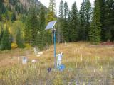
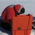
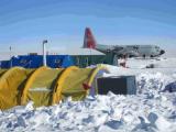
PASSCAL's Polar Group supported AGAP deployments in one of the most extreme polar environments on the planet.

Results are now emerging from the AGAP Project, funded by the National Science Foundation through its Office of Polar Programs. AGAP, which stands for Antarctica's Gamburtsev Province, has been probing the Gamburtsev mountain range for years. These mountains, completely covered by Antarctic ice, were not even discovered until 1958. New data now coming out are showing that these mountains have a youthful topography much like that of the Alps in Europe, and have not been weathered significantly.  Furthermore, the history of the root of the range can now be tracked back to one billion years in the past, with major rejuvenation events in the Permian and Cretaceous periods (~250 and 100 million years ago respectively). One reason the Gamburtsev range is important is that it is believed to be the initial site of Antarctic ice-sheet growth during major climatic changes some 35 million years ago.

Researchers Andy Nyblade of Penn State and Douglas Wiens and Patrick Shore of Washington University in St. Louis are part of the seismic portion of the project, called GamSeis. The IRIS/PASSCAL Instrument Center provided an array of broadband seismic stations used for the project by Wiens and Shore, along with Penn State's Nyblade, and Masaki Kanao of the National Institute of Polar Research (NIPR).

Related categories:

PASSCAL's Polar Group Revs Up for Antarctic Summer

This is the time of year when the Polar group at PASSCAL is busy deploying teams to the Antarctic. Since polar conditions make for difficult site installations, PASSCAL is pleased to present the following instructive videos of Antarctic station deployments.

Courtesy of Audrey Huerta of Central Washington University, here is a time-lapse video of the difficult installation of a POLENET seismic system on a rock surface at Miller Ridge in the Transantarctic Mountains. This installation took about 4 hours in real-time. You will see shadows encroaching as the sun sets toward the end of the four-minute video.

Seismic Community Responds to Virginia Earthquake in a Big Way

When the earth shook near Richmond, Virginia on August 23, 2011 at 1:51 PM EDT (17:51:04 UTC), millions of inhabitants of the eastern seaboard were surprised by the magnitude 5.8 tremor. The seismic community has responded in force, rapidly deploying dozens of new stations to record aftershocks of this rare event. (The largest previous earthquake in Virginia's history was a magnitude 5.9 event in 1897.)

This  image, provided by the National Park Service, is one of three or four "significant" new cracks in the Washington Monument. The picture was taken from a Park Service helicopter. The Monument is being closed to the public indefinitely.

Related categories:

2011 Seismic Instrumentation Technology Symposium Presentations Available On-Line

The 2011 Seismic Instrumentation Technology Symposium was held at Albuquerque Marriott on June 16 - June 17, 2011. This was the second joint Seismology/Earthquake Engineering/DOD symposium on seismic instrumentation technology.  The symposium theme was exploration of emerging instrumentation technologies providing solutions for key technical challenges in observational seismology. Symposium presentations highlighted operator perspectives on these challenges, as well as on emerging technologies in the thematic areas of communications, power, and timing. The symposium focused on creating and facilitating a dialog between academia, industry, and others.

Related categories:

PASSCAL Obtains New Automated Seismic Source

PASSCAL has purchased its first fully automated seismic source, a Propelled Energy Generator, model: PEG-40Kg manufactured by R.T. Clark Companies, Inc. The system is light weight, and highly portable, and is designed to easily mount onto a truck or SUV hitch. Seismic energy is produced when  a large hammer mass weight is propelled by an elastomer band (i.e. a very large rubber band) onto an impact plate, producing an impact frequency range of 10-250Hz. The source is controlled with a hand held motor controller,  and can operate in single cycle or continuous cycle mode. The device is powered by a 12V large capacity battery (car battery).  The PEG-40Kg was received, assembled, and field-tested by  PASSCAL staff on June 23rd-28th, 2011.

Related categories:

IRIS/PASSCAL Intern Cuts Her Teeth on TESGM Project Fieldwork

IRIS/PASSCAL summer intern Jennifer Tarnowski is learning the ropes of a seismology career by working at the PASSCAL Instrument Center at New Mexico Tech, and also by participating with hands-on efforts in the field.  Jennifer recently participated in fieldwork supporting the Topographic Effects in Strong Ground Motion project (TESGM, PASSCAL project 201109) in early July, along with principal investigators Brady Cox,  University of Arkansas, Adrian Rodriguez-Marek, Virginia Tech., graduate student Clinton Wood, University of Arkansas, Robert Kent of the Network for Earthquake Engineering Simulation (NEES), and Steve Azevedo, IRIS/PASSCAL.

PASSCAL and EMRTC help BBC explain internal structure of Earth

In early May, a team from the British Broadcasting Corporation (BBC) visited New Mexico Tech to use school facilities to support a new documentary on the current state of knowledge about the Earth's core.  Since seismology is the only practical method for probing the Earth's core, the team arranged the support of two of New Mexico Tech's facilities, the Energetic Materials Research and Testing Center (EMRTC), and the Program for Array Seismic Studies of the Continental Lithosphere (PASSCAL), to demonstrate how the seismic waves from earthquakes or man-made explosions can travel through the Earth, and be used as a subsurface probing tool. The team was assisted by Dave Thomas and Mouse Reusch from PASSCAL, and Richard Aster from the NMT Earth and Environmental Science department.

Related categories:

Visitors from Ecuador

Three engineers from the Escuela Politecnica Nacional Ecuador, Instituto Geofísico, spent the first two weeks of May here at PASSCAL. They are planning a network of 63 permanent broadband stations, 25 emergency sites, and 70 accelerometer stations in Ecuador. These stations will be used to monitor volcanic activity and seismic events. Ecuador is home to more than 20 volcanoes, so this is an important undertaking not only for the scientific knowledge it will provide, but also for the safety of the Ecuadoran people.

PASSCAL supports Salton Seismic Imaging Project (SSIP)

Six PASSCAL staff members were in Southern California this March to support the Salton Seismic Imaging Project (SSIP).  The project is funded by NSF through both the MARGINS Program (now GeoPRISMS) and the EarthScope Program, and funded by the U. S. Geological Survey through the Multi-Hazards Demonstration Project. The project includes researchers from Virginia Tech, Caltech, the USGS, and Mexican partner institutions CICESE and UABC, Mexicali.

Related categories: