Bighorn Arch Seismic Experiment: Results

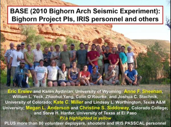
In 2010, a group of seismologists deployed several hundred sensors across Wyoming and Montana as part of EarthScope's Bighorn Project and the Bighorn Arch Seismic Experiment (BASE). IRIS/PASSCAL supplied instruments and expertise as part of this large effort, which included scientists from CIRES at University of Colorado Boulder(1), the Department of Geology at Colorado College(2), the Department of Geology and Geophysics at the University of Wyoming(3), and the Department of Geology and Geophysics at Texas A&M University(4). The Principal Investigators included Anne F. Sheehan(1), Megan L. Anderson(2), Eric A. Erslev(3), Kate C. Miller(4), and Christine S. Siddoway(2). William L. Yeck(1), the lead graduate student from UC Boulder, provided analysis and support included in this article. Additionally, numerous students contributed to the effort. The team's recent publication, "Structure of the Bighorn Mountain region, Wyoming, from teleseismic receiver function analysis: Implications for the kinematics of Laramide shortening," is available from AGU Publications (Full, PDF).
|
Dr. Eric Erslev of the University of Wyoming discusses the project and its results in an IRIS webinar, "The Rocky Mountain Thrust Belt of Wyoming: Collaborative Structural Geology and Seismology," published on Nov 12, 2015. Basement-cored uplifts are a puzzling feature of plate tectonics because they occur far from plate boundaries. The Laramide Bighorn Arch in Wyoming is an archetypal basement-involved foreland arch, and is an excellent location for investigating such structures. The Laramide orogeny was an episode of mountain building in western North America, starting in the Late Cretaceous, ~ 70 to 80 million years ago, and ending 35 to 55 million years ago. There has been very little mountain building or other deformation in the region since the Laramide epoch. |
 |
|
Data were acquired from 239 seismic stations in the Bighorn region of Wyoming and Montana. The instrumentation included 29 EarthScope Transportable Array (TA) broadband stations, 38 BASE broadband stations (data set XV 2009–2010 at Incorporated Research Institutions for Seismology Data Management Center (IRIS DMC), dx.doi.org/doi:10.7914/SN/XV_2009), and 172 BASE short-period stations (data set ZH-2010 at IRIS DMC, dx.doi.org/doi:10.7914/SN/ZH_2010). |
|
|
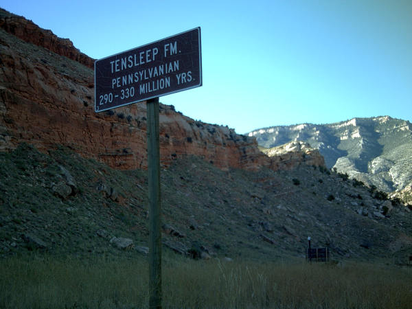
The Tensleep Formation, a Pennsylvanian sandstone, is of particular interest because it was horizontal prior to Laramide shortening. Its current structure is therefore largely the result of Laramide-related deformation. The base of the thin Tensleep Formation marks one of the largest velocity contrasts in the basins and is therefore a target for receiver functions. The Tensleep Formation is underlain largely by high-velocity carbonates, 6.4–7.0 km/s, and is similar to the velocity of Precambrian crust. |
 |
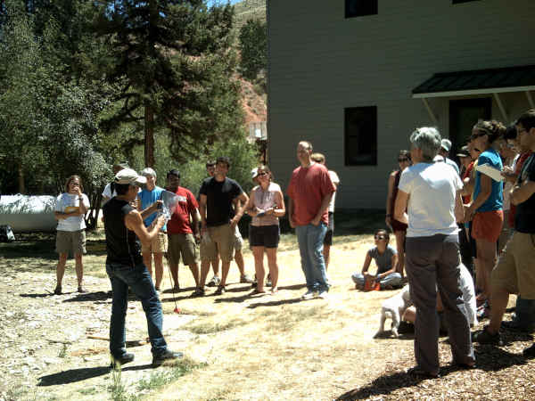 |
Prior to deployment, IRIS/PASSCAL's Willie Zamora instructed team members on how to hook up the instruments, and how to check their functionality in the field. PI Kate Miller of TAMU is in the white shirt to the right. |
|
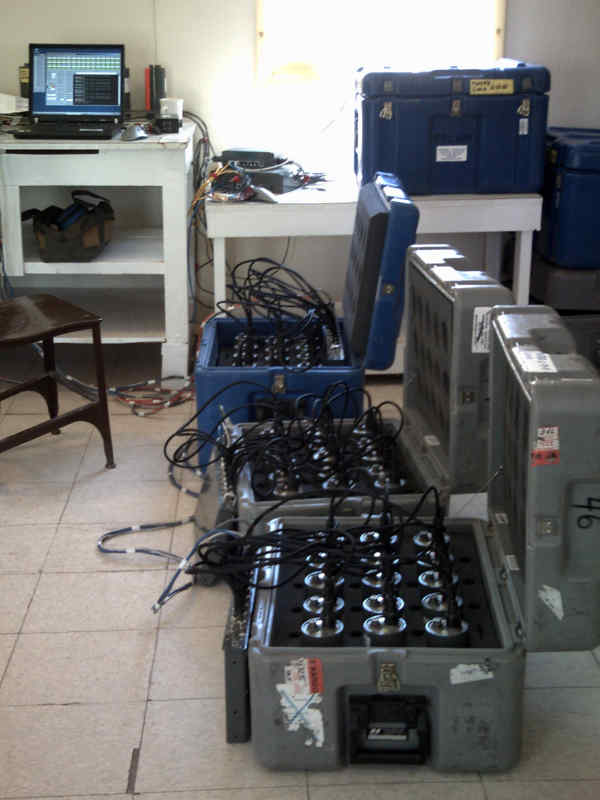
IRIS/PASSCAL personnel programmed Texans by the hundreds prior to the deployment. This picture shows the instrument staging station in Shell, Wyoming. |
 |
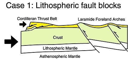 |
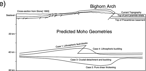
Four hypotheses were considered for the configuration of the Mohorovičić discontinuity (usually referred to as the Moho, the boundary between the Earth's crust and the mantle) beneath the Bighorn arch. In Case 1, the lithospheric fault block model, reverse faults penetrate the entire lithosphere. This model predicts discrete offsets of the Moho beneath the west-central Bighorn Arch, as shown at left.
|
|
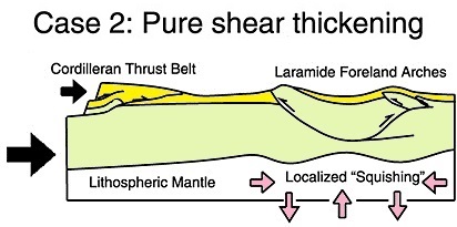
The second hypothesis considered was pure shear thickening. In the Case 2 model, the upper crust buckles and undergoes fault-propagation folding, while a ductile lower crust accommodates strain with pure shear thickening. The result is a thickened and downward bulging crust that accommodates both ductile and brittle shortening. This model predicts a crustal root underneath the Bighorns, as shown at right. |
 |
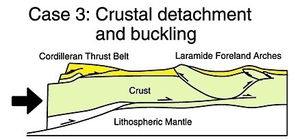 |
A third model predicts buckling and fault-propagation folding in the upper crust, driven by a detachment in the lower crust. Fault breakthrough and fault-propagation folding after the initial buckling of the upper crust can account for the asymmetry seen in many Laramide foreland arches. Since the major horizontal detachment lies in the lower crust, the crust and mantle below the detachment would be largely unaffected by the upper crustal shortening. For the Case 3 model, the current day Moho geometry would be dominated by its pre-Laramide geometry, as shown at left. |
|
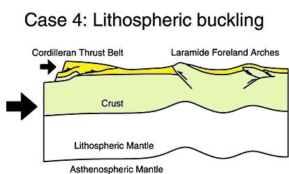
In a lithospheric buckling model, the lithospheric mantle buckles in response to horizontal compression. The Case 4 model predicts congruent folding of the surface and the Moho, as shown at right. |
 |
|
|
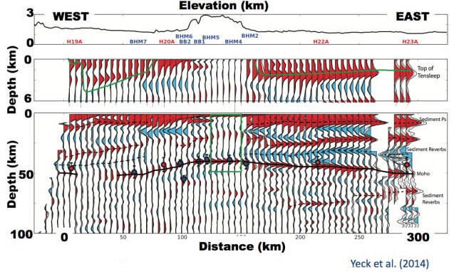
This plot shows Receiver functions for the Short Period H-K Sequential CCP Stack The top of the Tensleep formation is indicated by the green line at a depth of a few km. The Moho itself appears as a black line at ~ 50km depth in the figure at left. The upwarp of the Moho under the Bighorns rules out pure shear thickening and shortening at depth (Case 2); this mechanism requires a crustal root under the range, which is not evident in the results. Additionally, there was no evidence for substantial offsets in the Moho as might be expected from faults penetrating it, ruling out the hypothesis of lithospheric fault blocks (Case 1). The buckling hypothesis (Case 4) doesn't fit the data either. Map view images of the Moho upwarp shows that it does not follow the topograpy of the region. It also does not match the dip of the Tensleep under the Powder River basin--with buckling, the pre-mountain building surface (Tensleep) would be expected to be parallel to the Moho, which it is not. The team's final conclusion was that a detachment is necessary to explain all the observations. The data provide support for Case 3, crustal detachment and buckling. |
|
This figure shows the Bighorn Arch geometry based on Stone [1993], and indicates Moho geometries predicted from the above models. The team's results point to crustal detachment and fault-propagation folding as the primary mechanism for building the Laramide Bighorn Arch (Case 3). |
 |
 |
The result of the project includes new insights into the formation of mountain ranges like the Bighorn Arch in regions of the craton far from active subduction zones. |
Citations:
- Yeck, W. L., A. F. Sheehan, M. L. Anderson, E. A. Erslev, K. C. Miller, and C. S. Siddoway (2014), Structure of the Bighorn Mountain region, Wyoming, from teleseismic receiver function analysis: Implications for the kinematics of Laramide shortening, J. Geophys. Res. Solid Earth, 119, 7028–7042, doi:10.1002/ 2013JB010769.
- FDSN Network Information XV (2009-2010): Collaborative Research: Geometry and kinematics of basement-involved foreland arches:Insights into continental processes from Earthscope. International Federation of Digital Seismograph Networks. Other/Seismic Network. doi:10.7914/SN/XV_2009.
- FDSN Network Information ZH (2010): Collaborative Research: Geometry and kinematics of basement-involved foreland arches: Insights into continental processes from Earthscope. International Federation of Digital Seismograph Networks. Other/Seismic Network. doi:10.7914/SN/ZH_2010
