AGAP Project Reveals Details of Hidden Antarctic Mountain Range
PASSCAL's Polar Group supported AGAP deployments in one of the most extreme polar environments on the planet.
Results are now emerging from the AGAP Project, funded by the National Science Foundation through its Office of Polar Programs. AGAP, which stands for Antarctica's Gamburtsev Province, has been probing the Gamburtsev mountain range for years. These mountains, completely covered by Antarctic ice, were not even discovered until 1958. New data now coming out are showing that these mountains have a youthful topography much like that of the Alps in Europe, and have not been weathered significantly. Furthermore, the history of the root of the range can now be tracked back to one billion years in the past, with major rejuvenation events in the Permian and Cretaceous periods (~250 and 100 million years ago respectively). One reason the Gamburtsev range is important is that it is believed to be the initial site of Antarctic ice-sheet growth during major climatic changes some 35 million years ago.
Researchers Andy Nyblade of Penn State and Douglas Wiens and Patrick Shore of Washington University in St. Louis are part of the seismic portion of the project, called GamSeis. The IRIS/PASSCAL Instrument Center provided an array of broadband seismic stations used for the project by Wiens and Shore, along with Penn State's Nyblade, and Masaki Kanao of the National Institute of Polar Research (NIPR).
While the latest results are primarily from aircraft surveys using ice-penetrating radar, gravity and magnetics, the seismic data being collected will be used to help determine the mechanisms behind the uplift of the Gamburtsev Mountains, and their role in the development of the East Antarctic Ice Sheet.
The Airborne Geophysics portion (GAMBIT) of the project is being supported by the Lamont-Doherty Earth Observatory of Columbia University, the Center for Remote Sensing of Ice Sheets (CReSIS) at the University of Kansas, the Crustal Imaging & Characterization Team at the United States Geological Survey, the Earth Systems Research Center at the University of New Hampshire, the Center of Excellence in Remote Sensing Education and Research at Elizabeth City State University, the Polar Research Group at the Federal Institute for Geosciences and Natural Resources (BGR), and at the British Antarctic Survey (BAS).
 |
The AGAP (Antarctica's GAmburtsev Province) Logo. |
|
|
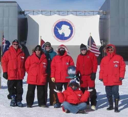
Part of the AGAP South/GamSeis crew at the South Pole. From left to right: Doug Wiens (WUSTL), Patrick Shore (WUSTL), Tim Parker (IRIS/PASSCAL), David Heeszel (WUSTL), Mouse Reusch (sitting)(then at PSU, now with IRIS/PASSCAL), Guy Tytgat (IRIS/PASSCAL) and Masaki Kanao (NIPR). Photograph courtesy Guy Tytgat. |
|
|
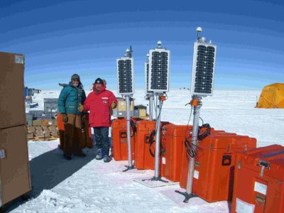
AGAP South camp: Assembling and testing the equipment before deployment. Tim Parker (left) and Masaki Kanao (right). Photograph courtesy Guy Tytgat. |
|
|
A 2008 article from NSF describes plans for AGAP, and Douglas Wiens describes the science behind the project in detail in this video interview. When not deciphering the intricacies of Earth's history, Wiens also serves as a member of the IRIS Board of Directors. More information on Wiens' career is available from a WUSTL news story, "Seismologist in the field." |

Further Reading:
